
The Government is yet to respond to a consultation (opens in new tab) on proposed SDS geographies that ended in March. Although 29 areas were then proposed, giving at least an indication of the likely direction of travel, the ongoing uncertainty will be particularly concerning for the eleven strategic planning authorities (Figure 1 below) that were not allocated to any of the proposed areas.
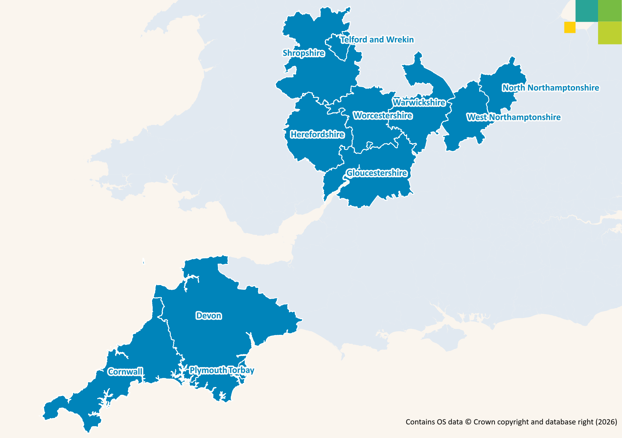
Below our Economics team explore possible solutions for the unallocated areas, primarily focusing on their geographic size and population.
Quick wins
There do appear a couple of obvious solutions. If Plymouth was grouped with Torbay and Devon the resulting geography would be larger than is covered by all but six of the areas that had been proposed, with more residents than live in 13 of them and a higher population density than three. Grouping North and West Northamptonshire would also be logical, since this would cover a sufficiently large area containing more residents than live in Tees Valley; Hull and East Yorkshire; or Cumbria.
Table 1: Benchmarking potential solutions for Plymouth, Torbay, Devon and Northamptonshire
| Plymouth, Torbay and Devon | Northamptonshire | |||
|---|---|---|---|---|
| Measure | Theoretical rank out of 31[1] | Measure | Theoretical rank out of 31[1] | |
| Area | 6,707 sq km | 7 | 2,364 sq km | 19 |
| Population | 1,256,388 | 17 | 823,787 | 28 |
| Population density | 187/sq km | 28 | 348/sq km | 22 |
Recognising precedents
The proposal for an area like Cumbria – with fewer than 514,000 residents – to have its own SDS does indeed set a precedent for more populated areas, since Gloucestershire, Warwickshire, Cornwall and Shropshire with Telford and Wrekin (the latter two historically part of the same county) would each have more residents if they were to be similarly covered by their own. They would also span larger areas than at least ten of those so far proposed, with population densities that would be far from the lowest seen.
Table 2: Key metrics for other potential geographies
| Area | Population | Population density | |
|---|---|---|---|
| Gloucestershire | 2,652 sq km | 671,908 | 253/sq km |
| Warwickshire | 1,975 sq km | 644,021 | 326/sq km |
| Worcestershire | 1,741 sq km | 624,209 | 359/sq km |
| Cornwall | 3,545 sq km | 584,782 | 165/sq km |
| Shropshire, Telford and Wrekin | 3,488 sq km | 532,540 | 153/sq km |
A final challenge
This would leave only Herefordshire, which has little more than a third (37%) as many residents as Cumbria so arguably does lack the critical mass to justify its own SDS. One option could be to combine it with Shropshire, Telford and Wrekin, since Shropshire was the main place of work for those travelling out of the county at the 2021 Census and it was equally its main source of labour, beyond its own residents.
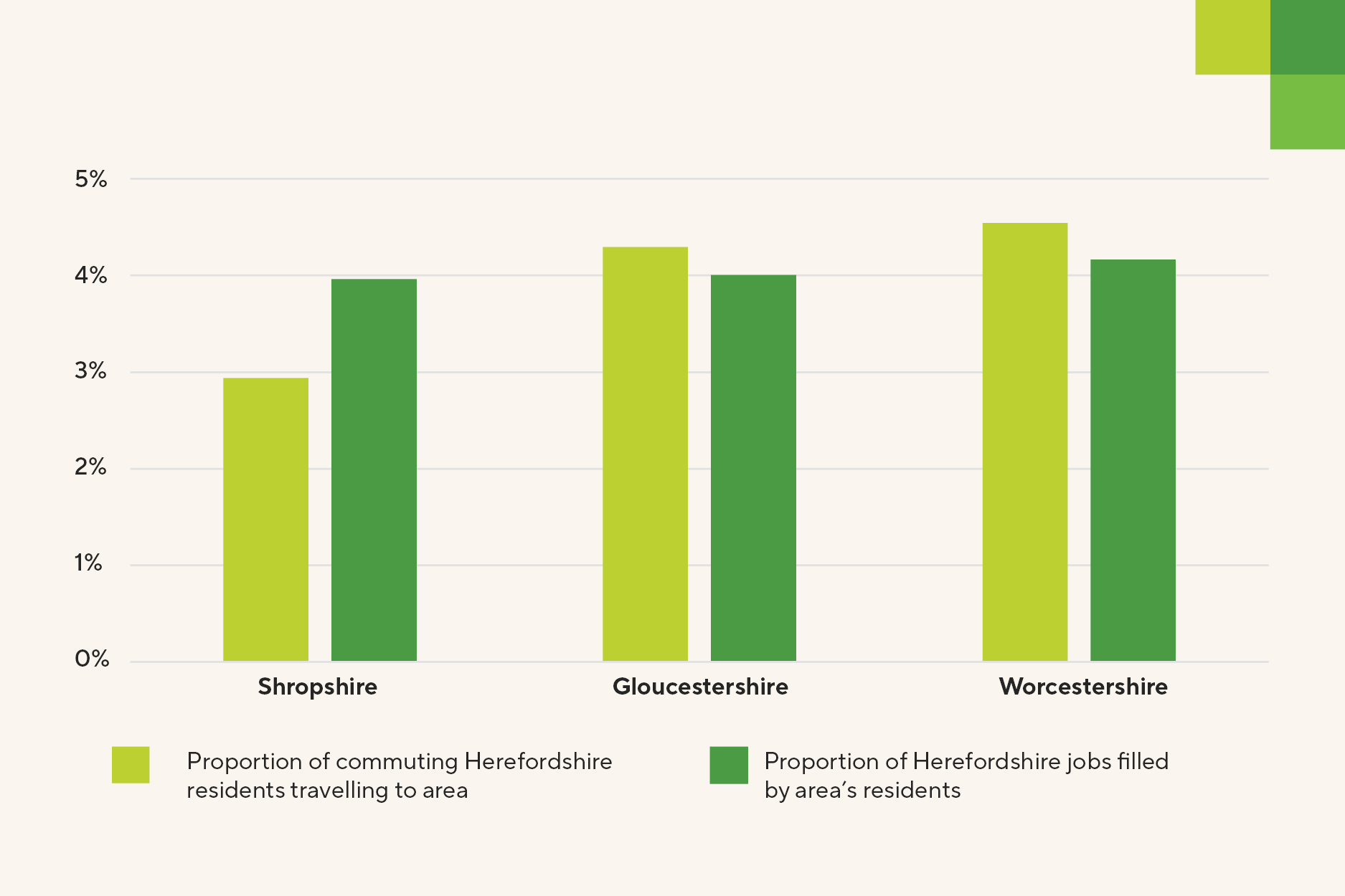
There are though also links with Worcestershire and Gloucestershire – especially when their individual authorities are combined – so a more radical solution could be to combine it with one or both of these areas, in a similar vein to how Wessex is uniting three areas that have, at least historically, been distinct. Combining Hertfordshire with Worcestershire or Gloucestershire, or both, would create an area that is geographically larger than the average of those proposed earlier this year (3,643 sq km) with more residents than at least three others.
Table 3: Alternative solutions for Herefordshire
| Herefordshire plus... | |||
|---|---|---|---|
| Worcestershire | Worcestershire and Gloucestershire | Gloucestershire | |
| Area | 3,920 sq km | 6,573 sq km | 4,832 sq km |
| Population | 816,748 | 1,488,656 | 864,447 |
| Population density | 208/sq km | 226/sq km | 179/sq km |
We await the Government’s confirmation of SDS geographies with interest and will be sharing further analysis of the challenges facing each area thereafter. Please contact Andrew Lowe to discuss SDS geographies in the meantime.
6 November 2026
[1] Comprised of 29 areas proposed by the Government plus the two others proposed here


